THE STROUD OZARK TRAILS OBELISK:
EXAMINING THE CLAIM THAT IT WAS RELOCATED
Was this marker moved to its present location from downtown Stroud? In his NRHP nomination for the roadway there, Michael Cassity presents circumstantial evidence to that effect, but a stronger case can be made that the surviving obelisk was built where it stands.

One newspaper article cited by Cassity describing the construction of the marker in the city of Stroud is dated May 1, 1920. In citing a second article, dated November 29, 1920, he states that the article relates to the erection of the same structure “or an identical Ozark Trail Monument near Stroud” (italics mine). In spite of this reference, and the fact that the articles were published six months apart, Cassity concludes that two separate markers were not constructed. His reasons are that:
There was no press coverage describing a second monument.
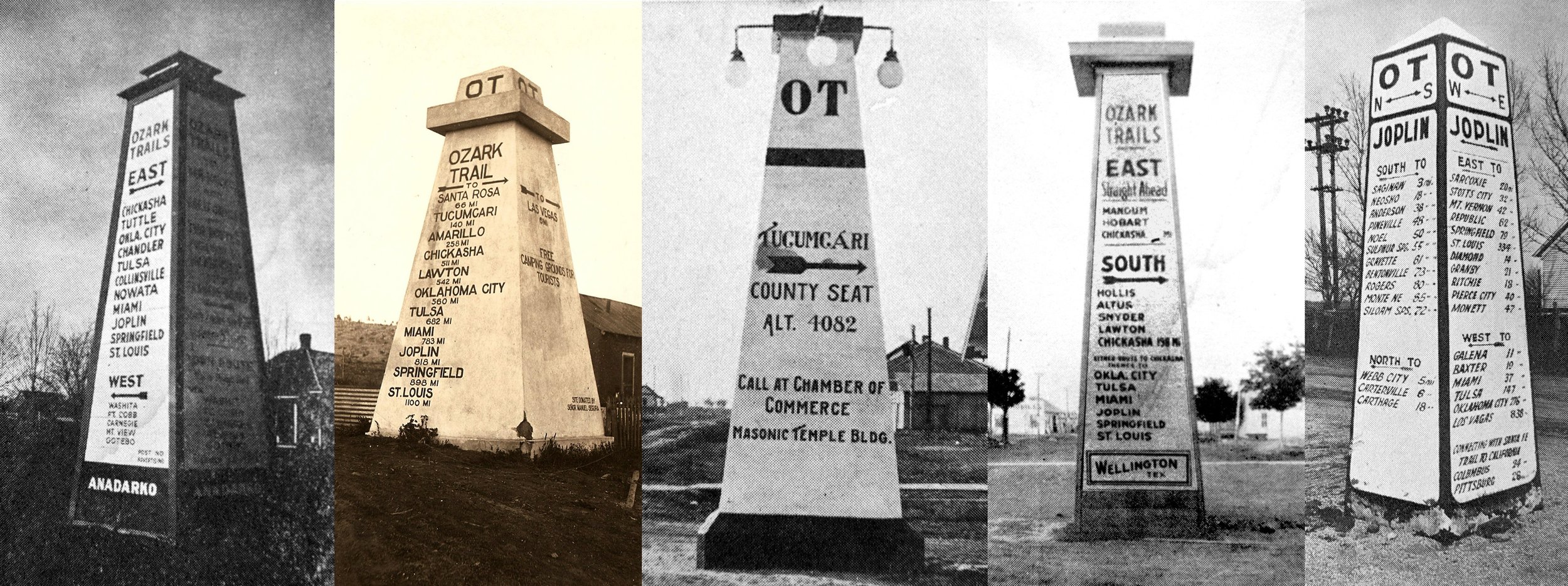
Monuments were most often erected in or near towns. (Note: the Stroud obelisk is near the town)
Association president Coin Harvey stated that he had arranged for the erection of 12 monuments in all between Las Vegas, NM and St. Louis. (This proved to be a gross underestimate; dozens were built)
Lighting of a monument in a rural setting would be difficult.
The county had set aside no parcel of land for the second marker, according to records. (This proved to be a non-issue for the Stroud obelisk).
No mention of the second monument is made in any of the reports relating to the first one.
The above points are almost entirely conjecture. Consider these counterpoints:
In fact, it was not out of the ordinary for obelisks to be built in rural settings, as in the case of Tampico, TX, Las Vegas, NM, Langston, OK, and many other locations.
It was not out of the ordinary for a city to have more than one obelisk in its vicinity (two at Miami, Oklahoma, are documented, and according to the Ozark Trails Association there were actually three there.
To date, no documentation has surfaced to support the moving of the Stroud city obelisk. It seems unlikely that such a spectacle would have taken place without any of the area newspapers taking notice. Certainly it would have intrigued readers more than construction of a second marker. Additionally, unearthing and moving a 20-foot concrete tower weighing 30 or more tons may not have been possible using city or county equipment of the day.
Coin Harvey stepped down in 1920, the year the Stroud markers were built. It is not known how many were actually built, but it was certainly multiples of 12. Considering all the branches of the OT network, the literature allows for more than 40. One source states that Harvey “originally envisioned” 12 markers. At the time Harvey made this statement, he was unaware of the extent to which the network would grow. A 1977 Master’s thesis on the OTA by Nan Marie Lawler of Arkansas states that once obelisks started going up, there was a demand by localities to have one. With dozens of OT branches stretching into seven states (Missouri, Arkansas, Oklahoma, Kansas, Colorado, Texas, and New Mexico), the total number will never be known.
Lincoln County historian and former county commissioner Don Sporleder emphatically states that the city marker was not moved, and cites family history involving friends of his parents who operated a store within view the rural obelisk. Additionally, since the intersection in which the obelisk stands is part of the right of way, it would not have been necessary to provide land for its erection. The site of the surviving Stroud obelisk was a junction of two branches of the OTA. It is these junctions, whether rural or urban, that were given priority for obelisk locations. It therefore makes perfect sense that an obelisk would stand at that location.
The Stroud obelisk that once stood at the city’s intersection of today’s Hwy.99 and Hwy. 66 was built in 1920. The US Highway uniform numbering system replaced named trails in 1926. Most towns, at some point after that, either destroyed or buried their OT markers or, in cases where they were preserved, laer moved them out of the intersections, in whole or in part, as in Dimmitt and Wellington, Texas. Some were simply left them in place permanently, as in Tulia and Tampico, Texas, Lake Arthur, New Mexico, and Langston, Oklahoma. In at least three known instances, the markers were buried right where they stood (Wellington and Quitaque, Texas, and Stratford, Oklahoma), and this was likely the fate of many more. It is nearly certain that the city of Stroud would not have undertaken to move or destroy their obelisk between 1920 and 1926, prior to the enactment of the uniform numbering system. Likewise, it is highly unlikely that they moved it after the OT was replaced by US 66 only to reinstall it on US 66 four miles away, especially in view of the mandate at that time to eliminate markers standing on US numbered highways. US 66 was relocated from the OT onto its present alignment in 1930, and this, more than likely, is why the surviving rural obelisk survived demolition.
Had the city chosen to move the city’s marker due to traffic concerns, it seems logical that it would have remained in Stroud rather than moved four miles away. A more plausible fate for the obelisk in Stroud is that it was destroyed or buried without fanfare and that no effort or expense was allocated to remove the more distant marker, particularly since plans were already underway for a permanent and paved alignment of US 66 .